SAEDNEWS: China has launched two AI-powered hyperspectral satellites capable of processing Earth-observation data directly in orbit, potentially reducing massive data transfers to the ground while laying the groundwork for a planned 258-satellite constellation.

According to SaedNews: China has taken another significant step toward turning space into a place where data is not merely collected, but analyzed before it ever reaches Earth.
Two hyperspectral satellites equipped with onboard artificial intelligence have been launched into orbit, introducing a computing model that could change the way large volumes of Earth-observation data are handled. Named Oriental Smart Eye 01 and 02, the satellites are designed to process information in space and transmit analyzed results instead of routinely sending huge amounts of raw imagery back to ground stations.
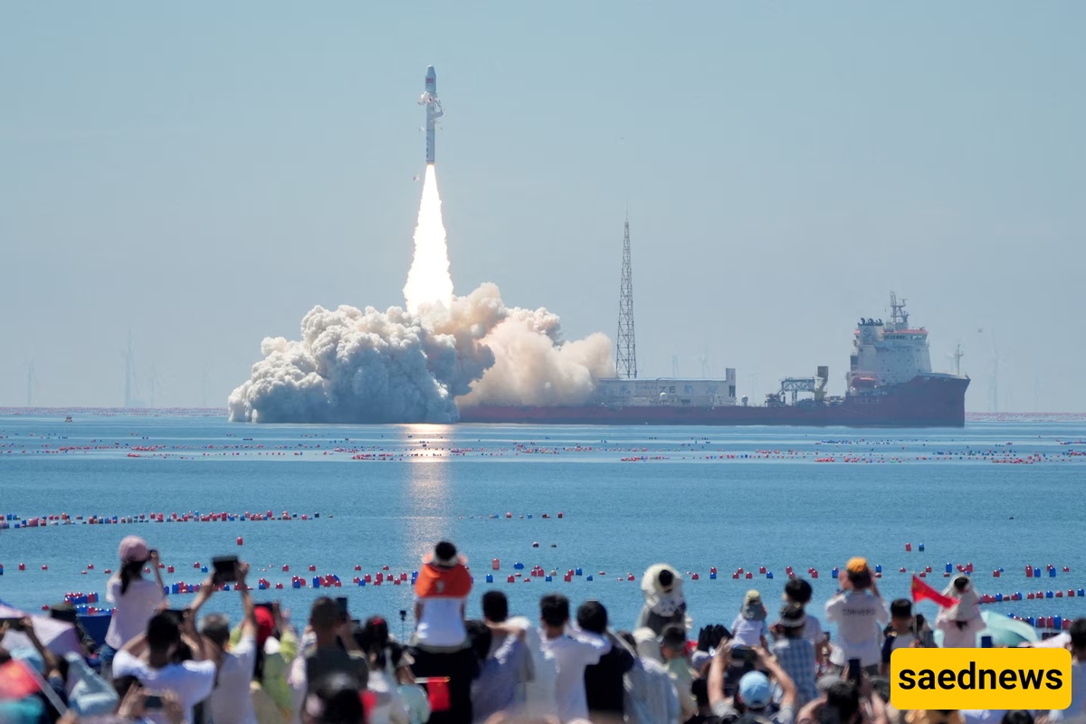
The mission was launched at 10:38 a.m. local time on Wednesday aboard the Smart Dragon-3 carrier rocket from offshore waters near Haiyang in China’s Shandong Province. The launch, managed by the Taiyuan Satellite Launch Center, was successfully completed, with both satellites placed into their designated orbits.
What makes the mission particularly notable is not simply that China has added two more Earth-observation satellites to orbit. The more consequential development is the computing capability being placed onboard.
Traditional remote-sensing satellites can generate enormous quantities of information. Images and other observations are generally transmitted to Earth, where computers and analysts process them. That approach can consume substantial communications bandwidth and create delays between collecting an image and extracting useful information from it.
The Oriental Smart Eye satellites are designed to tackle that bottleneck directly.
According to Song Bingchen, co-founder of Star.ai, the satellites have onboard AI computing capabilities reaching 400 trillion operations per second, or 400 TOPS. He said their processing power is comparable to roughly 20 to 30 high-performance laptops.
The idea is straightforward but potentially important: instead of treating orbit as a place where data is simply gathered, the satellites can perform analysis while still in space.
That means the ground may receive an answer rather than an enormous package of unprocessed information.
Peng Fuyu, an AI algorithm engineer involved with the satellites, said each spacecraft can generate hundreds of gigabytes of data every day. With onboard processing, however, images captured over 15-second periods can reportedly be analyzed within 10 to 15 minutes.
The result could be a dramatic reduction in the amount of information that needs to be transmitted to Earth—from several gigabytes to only tens of kilobytes or megabytes, according to the developers.
For satellite systems operating under bandwidth constraints, that difference is more than a technical curiosity. It could determine how quickly useful information can reach people who need it.
The Oriental Smart Eye satellites are also designed to go beyond conventional photography.
They reportedly have a 5-meter spatial resolution, a 300-kilometer imaging swath, and 22 calibrated spectral channels. These capabilities allow them to detect not only the visible shape and color of objects, but also what researchers describe as their “spectral fingerprints.”
Those fingerprints can provide additional clues about the condition and composition of materials observed on Earth, opening the door to more detailed analysis of land and natural resources.
Wang Mi, a professor at Wuhan University, described the satellites as representing a new standard compared with existing hyperspectral systems.
Their capabilities are not limited to daylight observations, either. During the day, the spacecraft can conduct hyperspectral imaging. At night, they can capture light emissions to monitor patterns of human activity in urban areas.
That combination could make the satellites useful across a wide range of applications, particularly when large amounts of information need to be analyzed quickly.
The new satellites are expected to work alongside OSE Gaofen-1, which was previously placed into orbit, creating a network aimed at supporting agriculture, environmental monitoring, mineral resources and maritime observation.
The two newly launched spacecraft also have specific international applications, according to their developers.
OSE 01 is being used within space cooperation between China and Indonesia. Its planned tasks include tracking crop growth and assessing risks associated with natural disasters in Indonesia.
OSE 02, meanwhile, has been designed as part of cooperation with Uzbekistan. Its mission focuses on monitoring cotton cultivation throughout the agricultural cycle, from planting through harvesting.
These applications illustrate why onboard AI processing matters. Agricultural monitoring, disaster assessment and environmental observation can generate enormous datasets, but users often need specific information rather than every image captured by a satellite.
If a spacecraft can identify and analyze relevant features before transmitting them, the amount of information sent to Earth can be significantly reduced.
The two satellites are only part of a much larger ambition.
China's OSE program is ultimately planned to include 258 satellites, with completion expected by 2030.
If that target is achieved, the project would represent a substantial expansion of China's space-based data-processing infrastructure. Instead of relying on isolated satellites, the country would have a broader constellation capable of collecting, processing and distributing information across multiple applications and regions.
The launch also highlighted China's integrated manufacturing approach at the Dongfang Aerospace Port industrial park in Yantai.
Wang Chao, a Shandong provincial official, said the integrated production model can accelerate deployment of satellite constellations while providing a stable foundation for the development of commercial spaceflight in China.
The broader significance of the mission therefore extends beyond the technical specifications of two spacecraft.
The emerging idea is that satellites may increasingly become intelligent computing platforms in their own right—observing Earth, deciding what information matters, processing it and sending only the most useful results back.
That could reshape the economics and speed of Earth observation as satellite networks grow.
China's latest launch offers an early glimpse of that transition: from satellites that primarily collect data to satellites that can increasingly understand and process it in orbit. Whether the planned 258-satellite constellation can turn that concept into a large-scale operational system will be one of the more closely watched developments in the country's commercial space ambitions.
For now, two satellites are already in orbit—and they are carrying something that is becoming nearly as important as their cameras: substantial computing power.