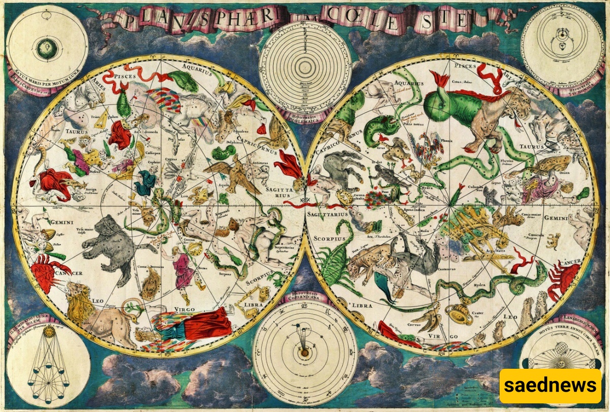
SAEDNEWS: The catalog of the Lost Star, compiled by Hipparchus—and regarded as humanity’s first known attempt to map the entire night sky—may have recently been discovered on a parchment manuscript preserved at Saint Catherine’s Monastery on Egypt’s Sinai Peninsula.
According to the Science and Technology Desk of SaedNews, in 2012, a manuscript specialist named Peter Williams noticed something unusual on the back of a Christian manuscript he was analyzing at the University of Cambridge.
By chance, he came across a fragment in Greek often attributed to Eratosthenes—the astronomer and chief librarian of the Library of Alexandria in early centuries AD.
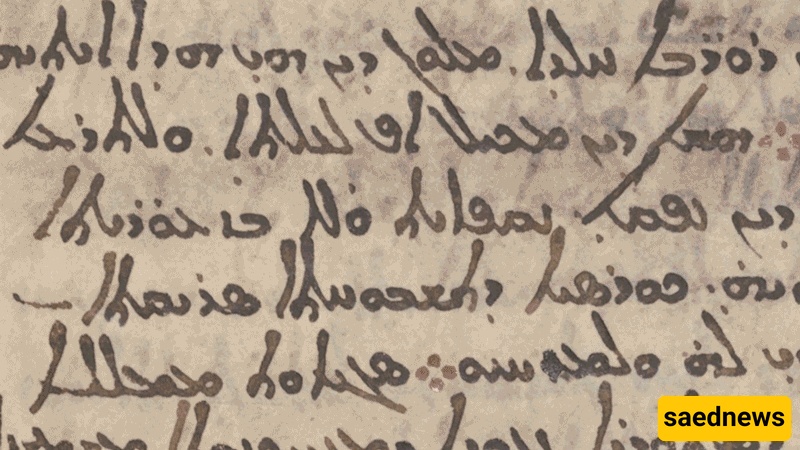
The nine-page manuscript underwent multispectral imaging in 2017, revealing erased writings beneath the original text. While unusual, this was not unprecedented; parchment was a valuable commodity, and reusing older sheets by scraping off previous text was common practice.
Upon closer examination, Williams found strange numbers on the pages stored at Saint Catherine’s Monastery. When he shared the manuscript with historians of science in France, researchers were astonished.
Victor Guisemberg, a historian at France’s National Center for Scientific Research (CNRS) in Paris, said, “We immediately realized we were looking at star coordinates,” though it remained unclear who had written them.
Experts know that the Greek astronomer Hipparchus worked between 162 and 127 BCE on a star catalog of the western sky. Several historical sources refer to him as the “father of astronomy,” and credit him with the first calculations of the Sun and Moon’s movements.
By examining the star map hidden behind the manuscript’s parchment, researchers reverse-engineered Earth’s position at the time the map was created. The star coordinates matched the expected positions of planets around 129 BCE, during Hipparchus’ lifetime.
Before this discovery, the oldest known star catalog was credited to Claudius Ptolemy in the second century CE—three centuries after Hipparchus.
There is additional evidence linking the manuscript to Hipparchus. The only other surviving work of Hipparchus is a commentary on an astronomical poem describing star constellations. Many coordinates he provides there match those in the Saint Catherine manuscript.

Although the readable coordinates in the manuscript only show a single constellation—Corona Borealis—researchers believe Hipparchus may have mapped the entire night sky.
Researchers have so far deciphered the manuscript as follows:
"The Northern Crown (Corona Borealis) in the northern hemisphere extends in longitude from the first degree of Scorpio to 10 ¼ degrees, 8 in the same zodiac sign, and in latitude from 6 degrees 49’ to 55 ¾ degrees from the North Pole. Within it, the star (β CrB) leads westward alongside the bright star (α CrB), the first star to rise, at 0.5 degrees in Scorpio. The fourth star, 9 (ι CrB), lies east of the bright star (α CrB) at 10° 49’ from the North Pole. The southernmost star (δ CrB) is the third from the bright star (α CrB) to the east at 55 ¾ degrees from the North Pole."
The symbols align with ancient Greek terminology: “longitude” measures east-west extent, and “latitude” describes north-south extent. Compared with Ptolemy’s later work, Hipparchus’ mathematics appear more accurate, differing by only one degree from modern measurements, suggesting Ptolemy did not copy directly from him.
Another manuscript—a Latin translation of Phenomena from the 8th century CE—uses similar structure and terminology to the Corona Borealis fragment, indicating it also derives from Hipparchus’ work.
Constellations mapped in the document include Ursa Major, Ursa Minor, and Draco, once again matching Hipparchus’ commentary.
The findings were published in the Journal for the History of Astronomy.